Best Weather in Canada
Canada is notorious for its weather. Google Canada or Canadians and you’ll get memes of Canadians doing crazy things in the deepest snow you’ve ever seen or doing something ridiculous involving ice. Is Canada really the Coldest?
Canada is notorious for its weather. Google Canada or Canadians plus “weather” and you’ll get memes of Canadians doing crazy things in the deepest snow you’ve ever seen or doing something ridiculous involving ice.

So it’s no wonder everyone thinks Canada is freezing all the time. And it’s no wonder one of the most popular questions Immigroup receives about Canada concerns our weather. Every prospective immigrant and many other people dreaming of Canada all want to know if they are going to freeze their asses off when they come here. So we thought it was about time we made a guide to living in Canada based on the weather.
Where You Should Live in Canada (If You Don’t Like The Cold) – The Guide
![Snow in Toronto By Diego Torres Silvestre from Sao Paulo, Brazil (89 Bus - Orion VII Next Generation Hybrid-Electric) [CC BY 2.0 (https://creativecommons.org/licenses/by/2.0)], via Wikimedia Commons](https://upload.wikimedia.org/wikipedia/commons/thumb/3/34/89_Bus_-_Orion_VII_Next_Generation_Hybrid-Electric_%285511695836%29.jpg/640px-89_Bus_-_Orion_VII_Next_Generation_Hybrid-Electric_%285511695836%29.jpg)
Snow in Toronto by Diego Torres Silvestre / Wikimedia Commons / CC BY 2.0
The short answer is that Canada can indeed be cold. Most of Canada experiences a winter that is unlike any you’ve ever experienced, unless you are from Russia, Alaska or Scandinavia…
The good news is that the vast majority of people in Canada do not live in the really cold parts! Yes, most of Canada’s biggest cities experience rather extreme winters, but the memes misrepresent this. Most of the time, we are not drowning in snow and ice. Most major cities experience 3-4 months of actual winter, from sometime in November or December to sometime in March or April (depending upon latitude and other factors).
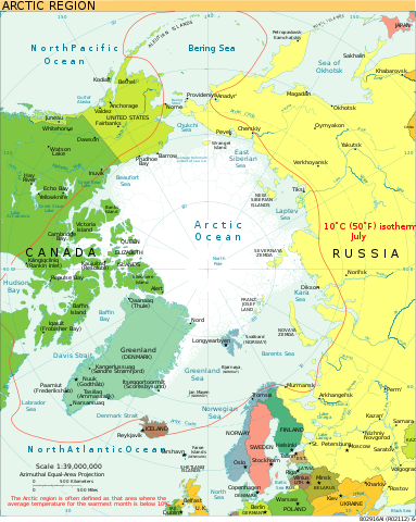
More good news is that one of Canada’s biggest cities experiences an extremely mild winter every year, one which doesn’t have snow most years. Canada’s climate is actually very diverse, among the most diverse climates in the entire world, with everything from arctic to temperate rain forest and near-desert:
![Climates of Canada By Adam Peterson (Own work) [CC BY-SA 4.0 (https://creativecommons.org/licenses/by-sa/4.0)], via Wikimedia Commons](https://upload.wikimedia.org/wikipedia/commons/5/54/Canada_koppen.svg)
by Adam Peterson / Wikimedia Commons / CC BY-SA 4.0
But most of Canada is pretty inhospitable. So where do you want to live?
7. The Worst Canadian Weather: The Arctic
The arctic climate is just unimaginably cold and is that way for almost all the year. When you’re north enough, there’s not even a summer: the temperature often doesn’t rise above freezing, even during the summer. The arctic climate zone experiences “polar night” too. That means that during the winter there are whole days of darkness. (The further north you go the more complete days of darkness there are in late December.)
The good news is that nobody lives here! You don’t have to either!
![Airport in Resolute By Northern Pix - https://www.flickr.com/people/northernpix/ (Airport terminal - Resolute Bay, Nunavut, Canada) [CC BY 2.0 (https://creativecommons.org/licenses/by/2.0)], via Wikimedia Commons](https://upload.wikimedia.org/wikipedia/commons/2/26/Airport_terminal_in_Resolute.jpg)
Resolute Airport by Northern Pix / Wikimedia Commons / CC BY 2.0
Climate data for Iqaluit Airport
| Month | January | February | March | April | May | June | July | August | September | October | November | December | Year |
|---|---|---|---|---|---|---|---|---|---|---|---|---|---|
| Average high (°C) | −22.8 | −23.3 | −18.3 | −9.4 | −1.2 | 6.8 | 12.3 | 10.5 | 5.2 | −1.0 | −8.3 | −17.0 | −5.6 |
| Average snowfall (cm) | 21.7 | 21.0 | 21.6 | 31.5 | 27.6 | 9.3 | 0.0 | 0.9 | 13.2 | 29.4 | 29.7 | 23.4 | 229.3) |
| Average snowy days (≥ 0.2 cm) | 12.2 | 11.6 | 12.7 | 13.4 | 12.0 | 3.9 | 0.1 | 0.5 | 7.2 | 13.7 | 13.8 | 12.3 | 113.5 |
Major Cities in the Arctic:
None. Iqaluit, the largest city in Nunavut, has a population of about 7,000 people.
Industries in the Arctic:
- Mining and natural resources:
- Natural gas and petroleum
- Gold
- Diamonds
- Hunting and fishing
- Tourism.
Why would you ever want to move to the Canadian Arctic?
In addition the experience of living above the Arctic Circle, moving to the arctic has a few advantages:
- living in a strange land with strange weather and sunlight extremes you’ll only experience in the extreme north or south of the planet
- living among a unique and ancient culture
- many employers offer isolation pay and other benefits, which can drastically improve your standard of living – in 2009 the Northwest territories had the highest per capita GDP in the entire country.
Canadian Arctic Immigration Programs:
- National Immigration Programs
- Immigrate Northwest Territories
- Nunavut does not have its own immigration program
- Yukon Immigrant Nominee Program
6. The Second Worst Canadian Weather: The Taiga (aka the sub-Arctic)
The Taiga is a boreal forest that stretches across the entire northern hemisphere.
![Taiga across the world By GeForce3 (Wiki Commons) [GFDL (https://www.gnu.org/copyleft/fdl.html) or CC-BY-SA-3.0 (https://creativecommons.org/licenses/by-sa/3.0/)], via Wikimedia Commons](https://upload.wikimedia.org/wikipedia/commons/a/a8/Distribution_Taiga.png)
by GeForce3 / Wikimedia Commons / CC BY-SA 3.0
As you can see by the picture above, the taiga forest makes up most of Canada – 60% of our land area. It runs from the treeline that marks the beginning of the arctic down to Cordillera in the west, the Prairies in the middle, and the southeastern and maritime climates in the east. The Boreal zone (see below) makes up the southern part of the Taiga.
The Taiga usually has a “continental climate,” which means winters below -3C and at least four months warmer than 10C. However, these averages are misleading and the winters are usually much colder and the summers much hotter. Cities located in the Taiga usually get only a limited amount of rain in the summer and snow in the winter, but the brief storms can be very extreme.
Edmonton is the largest Canadian city within the Taiga. Here’s its climate data:
Climate data for Edmonton (Blatchford Field), 1981−2010
| Month | January | February | March | April | May | June | July | August | September | October | November | December | Yearly Average |
|---|---|---|---|---|---|---|---|---|---|---|---|---|---|
| Average high °C | −6.0 | −2.7 | 2.2 | 11.2 | 17.5 | 21.0 | 23.1 | 22.6 | 17.1 | 10.4 | 0 | −4.5 | 9.3 |
| Average rainfall mm | 1.3 | 0.76 | 1.7 | 14.5 | 40.7 | 77.5 | 93.8 | 61.8 | 42.4 | 10.9 | 1.6 | 0.73 | 347.8 |
| Average snowfall cm | 24.5 | 13.4 | 17.4 | 15.3 | 4.9 | 0.0 | 0.0 | 0.0 | 1 | 11.6 | 19.1 | 16.4 | 123.5 |
| Mean monthly sunshine hours | 1.8 | 121.7 | 176.3 | 244.2 | 279.9 | 285.9 | 307.5 | 282.3 | 192.7 | 170.8 | 98.4 | 84.5 | 2,344.8 |
Major Cities of the Canadian Taiga:
| City | Rank Among Urban Areas in Canada | Rank in Province | taiga or Boreal? |
|---|---|---|---|
| Edmonton, Alberta | 5th | 2nd in Alberta (Capital) | Taiga? |
| Saguenay, Quebec | 29th | 7th in Quebec | Taiga? |
| Thunder Bay, Ontario | 33rd | 19th in Ontario | Boreal |
| Sudbury, Ontario | 36th | Greater Sudbury is 12th in Ontario | Boreal |
| Fort McMurray, Alberta | 47th | 5th in Alberta (but not technically classified as a city) | Taiga |
| Sault Ste Marie, Ontario | 48th | 25th in Ontario | Boreal |
| Grand Prairie, Alberta | 52nd | 7th in Alberta | Taiga? |
| North Bay, Ontario | 58th | 29th in Ontario | Boreal |
| Shawinigan, Quebec | 73rd | 18th in Quebec | Boreal |
| Rimouski, Quebec | 74th | 20th in Quebec | Boreal |
| Spruce Grove, Alberta (suburd of Edmonton) | 75th | 9th in Alberta | Taiga? |
| Prince Albert, Saskatchewan | 78th | 3rd in Saskatchewan | Taiga? |
| Lloydminster, on Alberta/Saskatchewan border | 84th | 12th in Alberta/10th in Saskatchewan | Taiga? |
| Leduc, Alberta (suburb of Edmonton) | 90th | 10th in Alberta | Taiga? |
| Timmins, Ontario | 91st | 34th in Ontario | Taiga? |
| Val-d’Or, Quebec | 96th | 32nd in Quebec | Taiga |
| Yellowknife, NT | Not in the top 100 | 1st (Capital) | Taiga |
Industries in the Canadian Taiga:
- Forestry (naturally)
- Mining and other natural resources
- Hunting and fishing.
Why settle in the Canadian Taiga?
The Taiga combines the best of Canada: wide open spaces with all the conveniences of modern life. But it’s empty and the winters are cold.
Canadian Taiga Immigration Programs:
Since most of the country has at least some Taiga in it, the area is served by most of the country’s immigration programs:
- National Immigration Programs
- Alberta Immigrant Nominee Program (AINP)
- British Columbia Provincial Nominee Program (BCPNP)
- Manitoba Immigration Nominee Program (MPNP)
- Newfoundland and Labrador Provincial Nominee Program
- Immigrate Northwest Territories
- Nunavut does not have its own immigration program
- Ontario Immigrant Nominee Program (OINP)
- Immigration-Quebec
- Saskatchewan Immigrant Nominee Program (SINP)
- Yukon Immigrant Nominee Program
The Boreal Forest (southern Taiga)
![Canadian Shield Green slash at English Wikipedia [CC BY-SA 3.0 (https://creativecommons.org/licenses/by-sa/3.0)], via Wikimedia Commons](https://upload.wikimedia.org/wikipedia/commons/thumb/5/5b/Flin_Flon_Wilderness_and_Outcrop.jpg/640px-Flin_Flon_Wilderness_and_Outcrop.jpg)
by Green slash / Wikimedia Commons / CC BY-SA 3.0
The boreal region is actually a sub-region of the Taiga and the division between the two climate zones is hotly debated. Some people would say the Taiga and the boreal are merely two names for the same region. Others suggest they are distinct regions. Most seem to agree that the Boreal makes up part of the southern Taiga. The Boreal is where most of the famous “Canadian Shield” is located.
Basically, the differences, if there are any, can be summed up like this:
- southern part of the Taiga
- warmer than the rest of the Taiga
- often rainier than the rest of the Taiga, especially the further east you go.
See the right-most column in the table of Taiga cities above to see our best guess as to whether a city is actually in the Boreal region or the Taiga.
5. The Cordilleran Climate Zone
The Cordilleran is a climate zone (really a series of climate zones) that runs down the west coast of North America from Alaska to Mexico, around the North American Cordillera, which includes the Rocky Mountains and some other, smaller ranges. As you can imagine, the further south you go, the warmer it gets. However, as with any mountain range, the higher up the mountains you are, the colder it will be, even in the summer.
![Rocky Mountains By al guy (talk · contribs) [GFDL (https://www.gnu.org/copyleft/fdl.html) or CC-BY-SA-3.0 (https://creativecommons.org/licenses/by-sa/3.0/)], via Wikimedia Commons](https://upload.wikimedia.org/wikipedia/commons/e/e0/RockyMountainsLocatorMap.png)
The Rocky Mountains by al guy / Wikimedia Commons / CC BY-SA 3.0
There’s no way to encapsulate all the different kinds of weather in these mountains as the weather varies drastically between places within this zone in a number of ways:
- the closer you are to sea level, the warmer it is, and the higher you are the colder it is but
- the further north you are, the colder it is, even in the summer and
- places on west-facing slopes get lots of rain whereas places on the east-facing slopes and on plateaus are usually dry, with very little rain or snow.
This means that temperature and precipitation can vary drastically over very short distances. You could really say that there are numerous micro-climates throughout the mountains, depending upon how far north you are, whether you are in the coastal mountains or the interior mountains, and whether you are on one side of the nearest mountains or the other. The weather in Kelowna, the biggest Canadian city in the region, only gives you an idea of what the weather is like in the Okanagan, a river valley in between the two ranges, and Canada’s best wine region.
Climate data for Kelowna International Airport, 1981–2010
| Month | January | February | March | April | May | June | July | August | September | October | November | December | Yearly Average/Total |
|---|---|---|---|---|---|---|---|---|---|---|---|---|---|
| Average high °C | 0.8 | 3.6 | 10.1 | 15.5 | 20.2 | 24.2 | 27.9 | 27.6 | 21.7 | 13.4 | 5.6 | 0.7 | 14.3 |
| Average rainfall (mm) | 8.9 | 10.0 | 16.9 | 28.3 | 39.2 | 45.9 | 37.2 | 32.1 | 31.7 | 29.1 | 24.4 | 7.6 | 311.3 |
| Average snowfall (cm) | 26.9 | 10.8 | 4.8 | 0.8 | 0 | 0 | 0 | 0 | 0 | 0.1 | 13.6 | 32.0 | 89.0 |
| Average monthly sunshine hours | 39.4 | 80.9 | 148.5 | 191.0 | 238.2 | 244.9 | 297.8 | 281.6 | 216.2 | 124.5 | 50.9 | 35.1 | 1,948.9 |
See the difference 2,400 kilometres makes:
Climate data for Whitehorse Airport, 1981–2010
| Month | January | February | March | April | May | June | July | August | September | October | November | December | Yearly Average/Total |
|---|---|---|---|---|---|---|---|---|---|---|---|---|---|
| Average high °C | −11.0 | −7.7 | −0.7 | 6.6 | 13.5 | 19.1 | 20.6 | 18.5 | 12.1 | 4.2 | −6.0 | −8.5 | 5.1 |
| Average snowfall (cm) | 25.4 | 18.3 | 14.8 | 7.2 | 2.0 | 0.0 | 0.0 | 0.3 | 4.7 | 18.6 | 27.0 | 23.5 | 141.8 |
| Mean monthly sunshine hours | 43.8 | 105.5 | 163.2 | 238.5 | 251.1 | 266.7 | 247.6 | 226.5 | 132.7 | 84.9 | 39.8 | 26.8 | 1,827.1 |
That’s a lot colder despite being the same “climate region.” As you can see, despite being classified as the same type of climate, the weather varies considerably from place to place.
Major Cities of the Western Cordillera (Canadian Rockies):
| City | Rank Among Urban Areas in Canada | Rank in Province |
|---|---|---|
| Kelowna, British Columbia | 21st | 7th in BC |
| Kamloops, British Columbia | 40th | 9th in BC |
| Prince George, British Columbia | 49th | 14th in BC |
| Vernon, British Columbia | 61st | 18th in BC |
| Penticton, British Columbia | 79th | 20th in BC |
| Whitehorse, Yukon | 98th | Largest city in the three northern territories (Capital of Yukon) |
Industries of the Western Cordillera (Canadian Rockies):
- Mining
- Forestry
- Healthcare
- Education
- Ranching
- Wine
- Government
- Service industry
- Hunting and fishing
- Adventure sports
- Tourism.
Why Settle in the Cordillera (Canadian Rockies)?
The Cordillera is probably the most beautiful part of Canada, featuring both the famous Rocky Mountains and the less famous but just as spectacular Coastal Mountains (and numerous smaller mountain ranges).
Because of the terrain, the region is a huge adventure sports region, featuring skiing in the winter and mountain biking in the summer, among many other sports.
The Okanagan, Canada’s famous semi-desert wine region, is also located in the Cordillera. At the bottom of the Okanagan it basically is a desert.
In southern British Colombia the weather is considerably milder than in the north of the province (or in Yukon) and the summers are lovely and warm (though forest fires are a real problem).
Immigration Programs of the Western Cordillera (Canadian Rockies):
- National Immigration Programs
- Alberta Immigrant Nominee Program (AINP)
- British Columbia Provincial Nominee Program (BCPNP)
- Yukon Immigrant Nominee Program
4. The Prairies
![Saskatchewan By BriYYZ (File:Flat (267441683).jpg) [CC BY-SA 2.0 (https://creativecommons.org/licenses/by-sa/2.0)], via Wikimedia Commons](https://upload.wikimedia.org/wikipedia/commons/thumb/2/2a/Southern_Saskatchewan_banner_Prairie.jpg/798px-Southern_Saskatchewan_banner_Prairie.jpg)
by BriYYZ / Wikimedia Commons / CC BY-SA 2.0
Perhaps almost as famous as the Rockies, Canada’s Prairies are the top of the “Great Plains,” a mostly flat expanse of land that stretches from northern Mexico to Alberta, running parallel to the Rockies, and from Montana in the west to Iowa and Missouri in the east. In Canada, they’re not quite as wide, stretching from Alberta to Manitoba.) It’s not all flat by any means – there are hills and there are numerous river valleys and “pot holes” – but it is more uniformly flat than most of the rest of North America. The Great Plains has been a great agricultural and ranching region for much of the history of both Canada and the United States.
The Prairies are famously dry, lacking the humidity that characterizes the rest of the populated parts of the country and generally getting less rain in the summers and snow in the winters. Though when the Prairies get storms, do they ever get storms:
A Chinook [Public Domain]
The Prairies are famous for their hail storms and flash floods.
Prairie winters are colder than the winters in southern Canada and on the coasts but, as the cliche goes, you don’t feel it as much because it’s a “dry cold.” (Likewise, in the summer, it’s hot, but you don’t feel the heat as much because “it’s a dry heat.”)
Climate data for Calgary International Airport
| Month | January | February | March | April | May | June | July | August | September | October | November | December | Year |
|---|---|---|---|---|---|---|---|---|---|---|---|---|---|
| Average high °C | −0.9 | 0.7 | 4.4 | 11.2 | 16.3 | 19.8 | 23.2 | 22.8 | 17.8 | 11.7 | 3.4 | −0.8 | 10.8 |
| Average rainfall (mm) | 0.1 | 0.1 | 2.2 | 10.8 | 46.1 | 93.9 | 65.5 | 57.0 | 41.7 | 7.5 | 1.5 | 0.3 | 326.4 |
| Average snowfall (cm) | 15.3 | 14.5 | 22.7 | 18.8 | 11.9 | 0.1 | 0.0 | 0.0 | 3.9 | 10.0 | 16.6 | 15.0 | 128.8 |
| Average monthly sunshine hours | 119.5 | 144.6 | 177.2 | 220.2 | 249.4 | 269.9 | 314.1 | 284.0 | 207.0 | 175.4 | 121.1 | 114.0 | 2,396.3 |
Major Cities of the Canadian Prairies:
| City | Rank Among Urban Areas in Canada | Rank in Province |
|---|---|---|
| Calgary, Alberta | 4th | 1st in Alberta |
| Winnipeg, Manitoba | 7th | 1st in Manitoba (Capital) |
| Saskatoon, Saskatchewan | 16th | 1st in Saskatchewan |
| Regina, Saskatcheawn | 18th | 2nd in Saskatchewan (Capital) |
| Red Deer, Alberta | 31st | 3rd in Alberta |
| Lethbridge, Alberta | 37th | 4th in Alberta |
| Medicine Hat, Alberta | 50th | 7th in Alberta |
| Brandon, Manitoba | 60th | 2nd in Manitoba |
| Moose Jaw, Saskatcheawn | 82nd | 4th in Saskatchewan |
| Okotoks, Alberta (suburb of Calgary) | 92nd | 8th* in Alberta (not technically a city) |
| Cochrane, Alberta (suburb of Calgary) | 97th | 9th* (not technically a city) |
Industries of the Canadian Prairies:
- Natural resources and Mining
- Agriculture
- Ranching
- Communications
- Government
- Healthcare
- Education and Culture
- Service industry
- Hunting and Fishing
- Tourism.
Reasons to Live in the Canadian Prairies:
Though the Prairies are often mocked by other Canadians for being so flat, they are not flat and actually feature some of the nicest scenery in Canada (though you have to look for it), including badlands and thousands of lakes and rivers.
Though it has stagnated in recent years, for much of the 21st century the Prairie Provinces boasted the strongest economy in Canada, so the area has exploded in terms of both population and services. Though full of the wide open spaces Canada and this region are famous for, Calgary, Winnipeg, Saskatoon and Regina are major cities and Calgary in particular boasts nearly everything you would want in a modern city, while being not as crowded as Canada’s very largest cities.
The economic boom also resulted in increased diversity in the major urban areas, meaning that a new immigrant is far more likely to find a pre-established community from their home country in one of the major Prairie cities than in the past.
Then there is the weather: though the storms are rough and the temperature extremes are legendary, if you prefer a place with less humidity this is absolutely the part of the country you want to live in.
Immigration Programs for the Canadian Prairies
- National Immigration Programs
- Alberta Immigrant Nominee Program (AINP)
- Manitoba Immigration Nominee Program (MPNP)
- Saskatchewan Immigrant Nominee Program (SINP)
3. Third Best Canadian Weather: Southeastern Climate Zone / Great Lakes / Quebec-Windsor Corridor
![Toronto By William B. Grice (Own work) [CC BY-SA 4.0 (https://creativecommons.org/licenses/by-sa/4.0)], via Wikimedia Commons](https://upload.wikimedia.org/wikipedia/commons/thumb/8/82/2014_Skyline_Toronto_ON.jpg/640px-2014_Skyline_Toronto_ON.jpg)
by William B. Grice / Wikimedia Commons / CC BY-SA 4.0
The southernmost area of Canada features the country’s warmest summers but still experiences some degree of the legendary Canadian winters (particularly in Quebec). The relatively mild climate and arable land make this region the most populous in the country by far: this region contains over 50% of the entire population of Canada on slightly more than 2% of the country’s land. Yes, Canada is large and so this part of Canada is still not as crowded as many other areas with 18 million people, but it’s still far and away the most crowded part of the country and the one least like the postcards.
Everyone moves to this part of the country: between 50-60% of new immigrants settle in this region most years. So it is crowded (for Canada).
The area between Windsor, Ontario and Quebec City experiences hot, humid summers and wet, snowy (and occasionally very cold) winters. The further northeast you go along the Great Lakes and the St. Lawrence River, the colder it gets. Here is the climate data for Canada’s two largest cities:
Climate data for Toronto (The Annex), 1981–2010
| Month | January | February | March | April | May | June | July | August | September | October | November | December | Yearly Average/Total |
|---|---|---|---|---|---|---|---|---|---|---|---|---|---|
| Average high °C | −0.7 | 0.4 | 4.7 | 11.5 | 18.4 | 23.8 | 26.6 | 25.5 | 21.0 | 14.0 | 7.5 | 2.1 | 12.9 |
| Average rainfall (mm) | 29.1 | 29.7 | 33.6 | 61.1 | 82.0 | 70.9 | 63.9 | 81.1 | 84.7 | 64.3 | 75.4 | 38.2 | 714.0 |
| Average snowfall cm | 37.2 | 27.0 | 19.8 | 5.0 | 0.0 | 0.0 | 0.0 | 0.0 | 0.0 | 0.1 | 8.3 | 24.1 | 121.5 |
| Average monthly sunshine hours | 85.9 | 111.3 | 161.0 | 180.0 | 227.7 | 259.6 | 279.6 | 245.6 | 194.4 | 154.3 | 88.9 | 78.1 | 2,066.3 |
and
Climate data for Montreal (McTavish Reservoir), 1971–2000
| Month | January | February | March | April | May | June | July | August | September | October | November | December | Yearly Average/Total |
|---|---|---|---|---|---|---|---|---|---|---|---|---|---|
| Average high °C | −5.4 | −3.7 | 2.4 | 11.0 | 19.0 | 23.7 | 26.6 | 24.8 | 19.4 | 12.3 | 5.1 | −2.3 | 11.1 |
| Average rainfall (mm) | 28.4 | 22.7 | 42.2 | 65.2 | 86.5 | 87.5 | 106.2 | 100.6 | 100.8 | 82.1 | 68.9 | 44.4 | 834.9 |
| Average snowfall (cm) | 45.9 | 46.6 | 36.8 | 11.8 | 0.4 | 0.0 | 0.0 | 0.0 | 0.0 | 2.2 | 24.9 | 57.8 | 226.2 |
| Average monthly sunshine hours | 99.2 | 119.5 | 158.8 | 181.7 | 229.8 | 250.1 | 271.6 | 230.7 | 174.1 | 138.6 | 80.4 | 80.7 | 2,015.2 |
Though only 500km east-northeast of Toronto, Montreal is much colder in the winter and basically twice as snowy as Toronto. So, even in this small climate region, where you live makes a big difference in terms of the weather.
Major cities of the Great Lakes Corridor:
So, most of Canada’s largest cities are in this one climate region. The Greater Toronto-Hamilton area is one of the 10 largest urban areas in all of North America<, its ranking dependant upon where you draw the boundaries. (Toronto is the 7th largest metropolitan area and the 9th largest urban agglomeration but the former definition does not include its furthest suburbs.) The table below is a conservative definition of the boundaries of the GTA. Many of the cities in the third table below would be considered by some to be within the GTA.
Cities in the Greater Toronto Area, Ontario
| City | Rank Among Urban Areas in Canada | Rank in Province |
|---|---|---|
| Toronto | 1st | 1st (Capital) |
| Mississauga | 3rd | |
| Brampton | 4th | |
| Markham | 7th | |
| Vaughan | 8th | |
| Plus numerous “towns” which are the size of cities but not classified as such in Ontario, such as Ajax, Oakville, Whitby, etc | ||
Canada’s second largest city is one of the 20 largest urban areas in North America.
Cities in the Greater Montreal Area
| City | Rank Among Urban Areas in Canada | Rank in Province |
|---|---|---|
| Montreal | 2nd | 1st |
| Laval | 3rd | |
| Longueuil | 5th | |
| Repentigny | 12th | |
| Brossard | 13th | |
| Granby | 14th | |
| Blainville | 15th | |
| Dollard-des-Ormeaux | 18th | |
| Saint-Eustache | 21st | |
| Mascouche | 23rd | |
| Mirabel | 24th | |
| Boucherville | 26th | |
| Vaudreuil | 29th |
Finally, the rest of the major cities in the Quebec-Windsor corridor. The provincial rankings refer to only the official city, not its urban area. It’s a long list. Skip it.
| City | Rank Among Urban Areas in Canada | Rank in Province | Included in Broad Definition of GTA or GMA? |
|---|---|---|---|
| Ottawa, Ontario/Gatineau, Quebec | 6th | 2nd in Ontario, 4th in Quebec (Ottawa is the capital of Canada) | No |
| Quebec City, Quebec | 8th | 2nd in Quebec (Capital) – urban area includes Quebec’s 8th largest city, Levis | No |
| Hamilton, Ontario | 9th | 5th – urban area includes Burlington, Ontario’s 28th largest city | In broadest definition of GTA |
| Kitchener-Cambridge-Waterloo, Ontario | 10th | Kitchener is 9th in Ontario, Cambridge is 16th, Waterloo is 20th | No |
| London, Ontario | 11th | 6th | No |
| Oshawa, Ontario | 14th | 13th | GTA |
| Windsor, Ontario | 15th | 10th | No |
| St. Catherines-Niagara Falls, Ontario | 17th | St. Catherines is 15th in Ontario, Niagara Falls is 23rd | No |
| Barrie, Ontario | 22nd | 14th | In broadest definition of GTA |
| Sherbrooke, Quebec | 23rd | 6th | No |
| Guelph, Ontario | 24th | 18th | No |
| Kingston, Ontario | 25th | 17th | No |
| Kanata, Ontario (suburb of Ottawa) | 26th | Officially part of Ottawa | No |
| Trois-Rivieres, Quebec | 27th | 9th | No |
| Milton, Ontario | 30th | 20th* (not technically a city) | GTA |
| Brantford, Ontario | 31st | 21st | No |
| Saint-Jean-sur-Richelieu, Quebec | 38th | 11th | GMA |
| Peterborough, Ontario | 39th | 24th | No |
| Saint-Jerome, Quebec | 41st | 15th | GMA |
| Sarnia, Ontario | 43rd | 27th | No |
| Chateauguay, Quebec | 44th | 22nd | GMA |
| Drummondville, Quebec | 45th | 14th | No |
| Belleville, Ontario | 46th | 31st | No |
| Welland-Pelham, Ontario | 51st | 30th | No |
| Granby, Quebec | 54th* (sometimes listed as its own urban area sometimes included in the GMA) | 16th | GMA |
| Beloeil, Quebec | 57th | 51st | GMA |
| Saint-Hyacinthe, Quebec | 59th | 18th | GMA |
| Cornwall, Ontario | 62nd | 32nd | No |
| Joliette, Quebec | 63rd | 55th | No |
| Victoriaville, Quebec | 66th | 22nd | No |
| Chatham-Kent, Ontario | 67th | Made up of smallers towns | No |
| Georgetown, Ontario | 68th | Technically a town | GTA |
| St. Thomas, Ontario | 69th | 36th | No |
| Woodstock, Ontario | 70th | 37th | No |
| Bomnaville-Newcastle, Ontario | 71st | Made up of smaller towns | In broadest definition of GTA |
| Salaberry-de-Valleyfield, Quebec | 72nd | 28th | GMA |
| Sorel-Tracy, Quebec | 76th | 29th | No |
| Leamington, Ontario | 81st | Techically a town | No |
| Stouffville, Ontario | 83rd | Techically a town | GTA |
| Orillia, Ontario | 85th | 38th | No |
| Stratford, Ontario | 86th | 37th | No |
| Orangeville, Ontario | 8th | Technically a town | In broadest definition of GTA |
| Bradford, Ontario | 89th | Technically a town | In broadest definition of GTA |
| Saint-Georges, Quebec | 93rd | 33rd | No |
| Keswick-Elmhurst, Ontario | 94th | Made up of smaller towns | In broadest definition of GTA |
| Bolton, Ontario | 95th | Technically a town | In broadest definition of GTA |
| Midland, Ontario | 99th | Technically a town | No |
| Innisfil, Ontario (suburb of Barrie) | 100th | Technically a town | In broadest definition of GTA |
In addition to all of these urban areas, this region of Canada includes many other communities which are just a little bit smaller than the cut off for the largest urban area list (24,000 inhabitants at the time of the last census, in 2016). So even if you do not choose to move to one of these communities, there are many, many other communities of size to choose from, most of which are not that far in driving distance from one of the major cities listed above.
Industries of the Great Lakes Corridor:
Historically, this has been where the jobs are in Canada for most of the last hundred years. Nearly every industry that exists in Canada is represented, to some degree or other, in the Great Lakes climate zone (even hunting). Just don’t come here to join the fishing industry.
However, due to this area’s popularity there is also a lot of competition, more so than anywhere else in Canada.
Reasons to live in the Great Lakes climate region:
With the hottest summers in Canada, this area is one of the most pleasant, at least during the summer time. It’s not the mildest climate – relative extremes are common, including extreme heat in summer and extreme cold in winter – but it is likely closer to what you’re used to than most of the above regions.
Because of the population base and the diversity of the major cities, this area of Canada has communities from most of the countries in the world, and of many, many ethnic groups. If you immigrate to this area you’re likely to find your ethnic group already established in multiple cities. (As a rule of thumb, the closer you are to downtown Toronto or downtown Montreal, the more diverse your community.)
There are more services here than anywhere else. Because Toronto is the largest city in the country, it has things that those other large cities in Canada do not (professional sports teams, world class cultural activities, the country’s greatest food scene).
Though living in an urban area, nature is still readily accessible, usually just an hour or less away by car. (And, the further you are willing to drive, the more it will seem like you are in the middle of nowhere.)
Drawbacks of living in the Great Lakes climate region
Though the hottest summers are here, this is not the mildest region in Canada. If you prefer your climate mild, you want to live on the west coast.
Because this is the most developed area in Canada, it has the most competition for jobs and the most urban sprawl; that means commutes among the worst in North America and there’s a high cost of living if you try to avoid those commutes by living near where you work.
Also, if you live in Ontario, it’s going to cost you a lot more than if you live in Quebec. Just FYI.
Immigration programs for the Great Lakes:
2. The Second Best Canadian Weather: Atlantic Maritime Climate Zone (The Maritimes)
Canada’s Maritime provinces are known for their culture and their milder climate. Unfortunately they’re also famous for their storms and their fog and general unpredictability of the weather.
![Cape Breton, NS By Kenny Louie from Vancouver, Canada (Taking in the scenery) [CC BY 2.0 (https://creativecommons.org/licenses/by/2.0)], via Wikimedia Commons](https://upload.wikimedia.org/wikipedia/commons/thumb/9/99/Taking_in_the_scenery_%282684286800%29.jpg/640px-Taking_in_the_scenery_%282684286800%29.jpg)
by Kenny Louie / Wikimedia Commons / CC BY 2.0
The Maritimes are the Atlantic provinces of New Brunswick, Nova Scotia and Prince Edward Island (and often the island of Newfoundland). They contain some of the oldest European settlements in Canada; they’re where the Vikings landed and where the Basques fished before the French came to Canada. As a result, they have a rich culture distinct from the rest of Canada.
However, due to the collapse of the Atlantic fishing industry and other industries during the 20th century, the Maritimes are also the poorest of the climate zones, for the most part.
The Maritimes experience warm, rainy summers and mild but very snowy winters. As with the rest of the country, the further north you go, the colder it will be. Here is the climate data for the Maritimes’ largest city:
Climate data for Halifax Citadel Hill, 1981–2010 normals
| Month | Jan | February | March | April | May | June | July | August | September | October | November | December | Yearly Average/Total |
|---|---|---|---|---|---|---|---|---|---|---|---|---|---|
| Average high °C | −0.1 | 0.4 | 3.6 | 8.7 | 14.4 | 19.6 | 23.1 | 23.1 | 19.3 | 13.4 | 8.1 | 2.8 | 11.4 |
| Average rainfall (mm) | 96.7 | 75.1 | 101.3 | 111.3 | 118.4 | 111.8 | 110.3 | 96.4 | 108.9 | 124.1 | 143.6 | 115.9 | 1,313.9 |
| Average snowfall (cm) | 43.1 | 35.0 | 31.2 | 7.0 | 0.8 | 0.0 | 0.0 | 0.0 | 0.0 | 0.1 | 7.8 | 29.2 | 154.2 |
| Mean monthly sunshine hours | 109.5 | 127.2 | 142.8 | 156.6 | 193.3 | 220.7 | 235.2 | 226.6 | 180.5 | 157.8 | 107.4 | 105.2 | 1,962.5 |
Note that the weather is considerably more extreme in Newfoundland than it is in the rest of the Maritimes.
Major Cities of Atlantic Canada (Maritimes):
| City | Rank Among Urban Areas in Canada | Rank in Province |
|---|---|---|
| Halifax, Nova Scotia | 13th (largest in the Maritimes) | 1st in Nova Scotia (Capital) |
| St. John’s Newfoundland and Labrador | 19th | 1st in Newfoundland and Labrador (Capital) |
| Moncton-Dieppe, New Brunswick | 28th | Moncton is 1st in New Brunswick and Dieppe is 4th |
| Fredericton, New Brunswick | 55th | 3rd in New Brunswick (Capital) |
| Saint John, New Brunswick | 56th | 2nd in New Brunswick |
| Charlottetown, Prince Edward Island | 65th | 1st in PEI |
| Cape Breton-Sydney, Nova Scotia | 88th | 2nd in Nova Scotia |
| Quispamsis-Rothesay, New Brunswick (suburb of Saint John) | 98th | Quispamsis is the 2nd largest town in New Brunswick, Rothesay is the 3rd |
Industries of Atlantic Canada (Maritimes):
- Agriculture
- Fishing
- Forestry
- Mining and other natural resources
- Service industry
- Film
- Tourism
Reasons to settle in the Maritimes:
Outside of Quebec City, the Maritimes has the oldest permanent European culture in Canada and is known for its traditions and friendliness.
The weather in the Maritimes is milder than all other parts of Canada save the West Coast (see below) but infamously features extreme weather, especially in the winter when massive storms shut down entire cities for days.
The Maritimes are one of the prettiest parts of Canada and one of the only two areas of the country where you can go to the beach on the ocean. (The water is usually pretty cold, though.)
The Maritimes is the most affordable climate zone in Canada, with certain costs of living (such as housing) often way, way lower than the rest of the country. Salaries, however, are often correspondingly lower as well. It is easier to move to the Maritimes from another part of Canada than it is to move from the Maritimes to another part of Canada.
1. The Best Canadian Weather: Pacific Maritime Climate Zone (the West Coast)
If you’re immigrating to Canada but worried about the weather there is one place where you can avoid Canada’s legendary winters: the southern part of Canada’s West Coast, which includes the Lower Mainland and Vancouver Island, is Canada’s most mild climate – so mild there’s an actual rain forest – almost like it’s in another country. What’s the catch? You have to be okay with rain.
![English Bay By No real name given [CC BY 2.0 (https://creativecommons.org/licenses/by/2.0)], via Wikimedia Commons](https://upload.wikimedia.org/wikipedia/commons/thumb/8/80/English_Bay%2C_Vancouver%2C_BC.jpg/640px-English_Bay%2C_Vancouver%2C_BC.jpg)
by James Z / Wikimedia Commons / CC BY 2.0
The Lower Mainland, the name for a 36,000 square kilometre tract of flat land where the Fraser River meets the Pacific Ocean, has the mildest weather on the Canadian mainland due to Pacific Ocean currents and the mountain ranges behind it, and thus contains 60% of British Columbia’s population. Across the Georgia Strait is Vancouver Island (and many smaller islands), which experiences the mildest climate in the entire country (at sea level, not in the mountains) but is considerably more remote than the Lower Mainland, with expensive ferries and helijets being the only way to get back to the rest of the country.
This part of Canada is, in many ways, a paradise, allowing those who live in the region to get the best of both worlds: to enjoy the mildest weather in the country – and all that entails, including numerous beaches – but have easy access to winter sports, with the country’s most famous ski resort only a few hours away. Basically, you can enjoy the Canadian winter when you want to but live without it the rest of the year.
It’s not surprise that it has become one of the most popular destinations for new Canadians in recent decades.
This region of the country experiences warm summers with mild, rainy winters (with only the occasional snow). Check out this climate:
Climate data for Vancouver International Airport (Richmond), 1981–2010
| Month | January | February | March | April | May | June | July | August | September | October | November | December | Yearly Average/Total |
|---|---|---|---|---|---|---|---|---|---|---|---|---|---|
| Average high (°C) | 6.9 | 8.2 | 10.3 | 13.2 | 16.7 | 19.6 | 22.2 | 22.2 | 18.9 | 13.5 | 9.2 | 6.3 | 13.9 |
| Average rainfall (mm) | 157.5 | 98.9 | 111.8 | 88.1 | 65.0 | 53.8 | 35.6 | 36.7 | 50.9 | 120.7 | 185.8 | 148.3 | 1,153.1 |
| Average monthly sunshine hours | 60.2 | 91.0 | 134.8 | 185.0 | 222.5 | 226.9 | 289.8 | 277.1 | 212.8 | 120.7 | 60.4 | 56.5 | 1,937.5 |
The rule of thumb in avoiding the snow is twofold:
- the further up the mountain slope you live, the more likely you will get snow
- the further inland you are up the Fraser River, the more likely you will get snow.
Major Cities of Canada’s West Coast:
The West Coast contains Canada’s third largest urban area, containing many of the largest cities in BC:
Cities in the Greater Vancouver Area, British Columbia
| City | rank Among Urban Areas in CAnada | Rank in Province |
|---|---|---|
| Vancouver | 3rd | 1st |
| Surrey | 2nd | |
| Burnaby | 3rd | |
| Richmond | 4th | |
| Coquitlam | 6th | |
| Delta | 8th | |
| Maple Ridge | 13th | |
| New Westminster | 15th | |
| Port Coquitlam | 16th | |
| North Vancouver | 17th | |
| Port Moody | 18th |
The remaining major cities are all nearby, as this is a small climate region. As with the other tables, the ranking in the province is for the city, not the urban area around the city.
| City | Rank Among Urban Areas in Canada | Rank in Province | Location |
|---|---|---|---|
| Victoria | 12th | 11th (urban area also includes BC’s 23rd largest city, Langford) | Vancouver Island |
| Abbotsford | 25th | 5th | Lower Mainland |
| White Rock | 34th | 26th | GVA |
| Nanaimo | 35th | 10th | Vancouver Island |
| Chilliwack | 42nd | 12th | Lower Mainland |
| Courtenay | 64th | 25th | Vancouver Island |
| Campbell River | 77th | 21st | Vancouver Island |
| Mission | 80th | Technically a “district” | Lower Mainland |
Industries of Canada’s West Coast:
As Canada’s largest city west of Toronto, the Greater Vancouver Area is home to many, many different types of industries including but not exclusive to:
- Finance, including Insurance and Corporate Management
- Real Estate
- Natural Resources, particularly Forestry and Mining
- Film
- Hunting and Fishing
- Tourism.
Reasons to live on Canada’s West Coast:
The most obvious reason to settle here is the weather: with no true Canadian winter (one serious snow storm every few years) and few massive temperature swings, this area is one of those parts of the world where the seasons lose their meaning a little bit.
The area is one of the recreation capitals of Canada, featuring a more diverse array of recreation options during the winter than anywhere else in the country, and still plenty to do in the summer (when it’s not as hot as most of the rest of Canada).
Due to the area’s location, there are also unique job opportunities that are not available in the Prairies or in the Maritimes.
Reasons not to live on Canada’s West Coast:
It’s not all perfect. It rains all the time, and when it does snow the teeniest bit of snow paralyzes most communities as they are not prepared.
Also, compared to the rest of Canada, the Lower Mainland is actually quite crowded with a population density approaching that of southern Ontario’s. (Vancouver Island is considerably less dense but is also relatively more isolated.)